[ Update 2: Anaglyph 3D pops up Central Cambridge halfway down under Other Areas
Update 1: added four effects to enhance relief maps on mountain areas at the bottom ]
Last month's Story-in-a-map reminded me I created a number of map posters, as a mean to reach out to the community, where prints are better in town hall or small group presentations, as well as wall art.
East Anglia
Sea Level Rise Models
These were introduced in Medium and expanded in a story map. But maps' story-telling capacity in this story map resulted in a catalog of print maps. So-called papercut style highlight the progress of sea level rise models in North Cambridge and East Anglia.
- A4 96 dpi here (656 Kb) for low resolution leaflets (1:125,000 - ½ in./mi.)
- A4 300 dpi here (4.12 Mb) for high resolution leaflets (1:125,000 - ½ in./mi.)
- A1 300 dpi here (22.2 Mb) same as OS Landranger (1:50,000 - 1¼ in./mi.)
- A0 300 dpi here (36.4 Mb) same as OS Explorer (1:25,000 - 2½ in./mi.)
- above papercut map of all of East Anglia A4 portrait 300 dpi (9.26 Mb) here
- blue tone papercut map of all of East Anglia A4 300 dpi (8.98 Mb) here
- blue tone papercut map of N Cambridge A4 300 dpi (4.09 Mb) here
Affected Areas
Parishes affected by sea level rise models to support
cottenham.info submissions, and
storied here to promote situational awareness, get 120dpi A0 (11.5 Mb)
here and A4 (1.2 Mb)
here:
Pirate map for fun, get the 150dpi A4 (1.5Mb)
here:
Cambridge Colleges divestment campaign guide, get the 150dpi A4 (1Mb)
here:
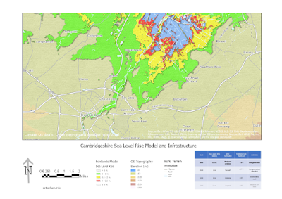
Cottenham inundation risk
Flood risk, infrastructure & topography showing at-risk areas, all PDFs handouts for local village council engagement
storied here:
- get A0 96dpi regional above poster here
- get A4 96 dpi village top left poster here
- get A4 96 dpi village top right poster here
- get A4 96 dpi village bottom left poster here
- get A4 96 dpi village bottom poster here
Digital Terrain Models
DEFRA offers almost countrywide coverage in 1 & 2 m. resolution digital terrain (topography) & surface (+ building + vegetation) models plus 25cm. along rivers & levees.
- DEFRA 1m. Digital Terrain Model in A4 landscape 300 dpi (5.26 Mb) here
- DEFRA 1m. Digital Surface Model in A4 landscape 96 dpi (7.28 Mb) here
Topography & Geomorphology
As mentioned in this
story map, "topographic inversion" is an optical illusion that relief appears inverted unless it's lit from the NW. And since most landscape is lit from the South in the Northern hemisphere, air photo and satellite imagery are prone to such 'inversion'. That led to this "upside down" poster to restore "right side up" relief, get the 150dpi A4 (2.28Mb)
here:
@StaridasGeo blog post post showed how to get "right side up" via edge detection & assigning 247° azimuth 47° elevation suitable for these latitudes, get the 150 dpi A0 (18.74Mb)
here:
Other areas
Cumbria
Top is Esri multi-directional hillshade and bottom is DEFRA 2m DTM, both with Esri terrain for misting and world imagery for land cover:
Central Cambridge
Another
@StaridasGeo's
blog posts used Blend mode to create Anaglyphs: while he used global scene on topography,
here is local scene on building elevations I had already used. As mentioned in both blogs, you need 3D specs w red and cyan, cheap cardboard ones available online - you can try also
cross-view - here it is with Castle Hill atop and Magdalene Bridge near centre, showing OS buildings & background, & DEFRA topography; view this
story map for how this helps situational awareness:
Rest of the World
Notice that in contrast to the Po Plain in the arc of the Alps below, the W CAN Prairies NE of the Rocky mountains show no misting: that's because the Foothills are a mile high!
Thanks John Nelson & Spiros Staridas for twitter discussions, & John Nelson carto tips.


No comments:
Post a Comment
Please send me a copy of your prospectus to