In the process of looking at land cover per previous post, I found Natural England's Natural Capital Atlas - their story map encouraged me to enter EsriUK's latest competition - their Esri dataset is accompanied by ample documentation under data.gov. To save us reverting to ArcMap, let's use the provided layer files and a file geodatabase in three simple steps to map our own region on ArcGIS Pro.
Note: file geodatabase and shape files can be used on other platforms: the GIS User Guide from here gives not only the metadata to style it, but also the methodology to recreate it with other datasets! You will see that data and styles are quite straightforward. Can you spot below the clue to an original map package, which it may be worth asking Natural England for?
File Geodatabase
First thing you notice is that the number of features pales in comparison to the number of layers.
That's because the tables themselves contain attributes classified by grouping in by feature: |
| click to enlarge |
Layer files
The simplest therefore is to grab all the layer files, post them on the map and group them by the HexGrid features. The guide pointed out above explains the hexagon binning used to derive these maps.
Here is the original ArcMap grouping for reference, again no need to use the old app:
 |
| click to enlarge |
You will get errors as the source doesn't match, but ArcGIS Pro no longer fixes broken links for all features as in ArcMap. Either you can choose which layers relate to your project - mountains or coasts were skipped here - or brew yourself a cuppa and traverse all of them, while you discover what they mean in the metadata folder...
Note: if you're handy at python or geoprocessing, you may automate that. I haven't found a way as GP appears to be geared towards portal / desktop not desktop / desktop, but stay tuned! And hint: the package mentioned above shows here under layer properties.
 |
| click to enlarge |
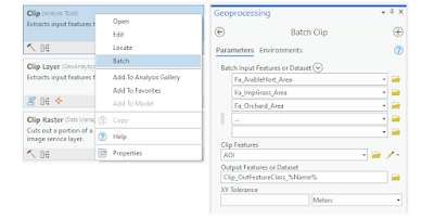
Clip to area
 |
| click to enlarge |
Note the interactive legend that allows you to query each item, say, the Outliers (>90 percentile in wine red and No Data in white). Also start with the documentation re: hexagon binning, with the County guide the easiest place to start: here is their GIS guide but do consult the originals here.
Correction
 |
| click to enlarge |
No comments:
Post a Comment
Please send me a copy of your prospectus to