Andrew Zolnai Blog
Maps, web maps & AI for public good
Showing posts with label
Kuwait
.
Show all posts
Showing posts with label
Kuwait
.
Show all posts
Sunday, 18 October 2015
GIS for oil spill modelling - Part II
›
This is a follow-up to Part I explaining oilspill modelling using NOAA Gnome modelling software and Kuwaiti ROPME data, all in the public d...
Saturday, 31 March 2012
iPad maps
›
Here is a small selection of mapping tools available on the iPad. Some are from the Appstore, others simply from the web. These are screen...
Saturday, 10 September 2011
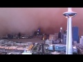
Be your own weatherman
›
Dust storms are what you look out for in Kuwait. The banner map was a very simple way for me to create my own weather map: where are the d...
Tuesday, 3 May 2011
Critical mass, satellite imagery and GIS
›
Satellite imagery has been around for almost as long as GIS, and the following may just make them so easy they finally gain momentum. The sa...
Saturday, 5 March 2011
Google Fusion Tables for Current Affairs
›
[ Update: I noted on many of my Google Fusion Table posts that, while the data are still on Google Drive for you to view, GFT no longer o...
Friday, 4 February 2011
IQPC show in Kuwait City
›
Attended this small and personable show and met some friends old and new - vendors were invited into the talks and plenty of time was left i...
Sunday, 5 December 2010
An excellent GIS repository
›
This summer I followed the ESRI User conference via twitter, which put me onto their excellent video resource page . That was great as it h...
›
Home
View web version