Look what I found!
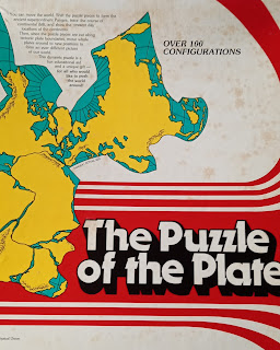
Having taken a vacation from work and social media, I found a puzzle box in my late Dad’s old office, while visiting my Mum:
The Puzzle of the PlatesSpilhaus Repeating World Maps
1985 American Geophysical Union
Created by Athelstan Spilhaus
 |
| Click to enlarge |
 |
| Click to enlarge |
It's a jigsaw puzzle with under 20 pieces, that illustrate the breakup of Pangea - more on Wikipedia - and allows continental plates to be moved around, with explanations I'll attempt to illustrate here.
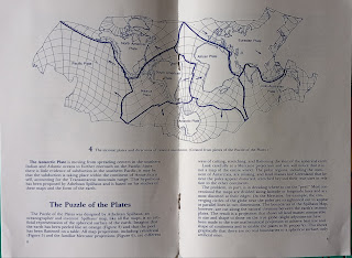
The booklet explains plate tectonics that were still quite new in 1985, as well as rudiments of projection explaining Spilhaus' choice in his atlas. Then they show the layout of the resulting map:
 |
| Click to enlarge |
This puzzle shows the globe's tectonic plates on an ocean-centric layout, emphasising the plate boundaries as edges of pieces, so you can shuffle pieces around to study how they fit together before and after the breakup of the Pangea super-continent around 200 million years ago. For reference, dinosaur extinction was 66 million years ago, and onset of vertebrates and plants 450 million years ago.
Shall we play?
First you assemble the edges like in any puzzle, then you fill in the rest, et voilà!
 |
| Click to enlarge |
Next you group them by plates, and see how the resulting holes illustrate the plate movements and oceans opening and closing. Here is the classic fit before the Atlantic Ocean opened:
 |
| Click to enlarge |
Finally you remove the bordering blocks and move the plates around:
- move Pacific plate on the other side of the Eurasian plate:
 |
| Click to enlarge |
- flip American plate atop Eurasian plate:
 |
| Click to enlarge |
 |
| Click to enlarge |
Notice the mountain ranges seen faintly in grey line up perfectly from S America thru Antarctic and E. Australia: the backbone of another super continent called Gondwana, the reconstruction of which was the birth of plate tectonics illustrated by this atlas...
In early 80's I was co-grad student at Queen's Uni. in E. Canada with Maarten de Wit in the link above, RIP Apr. 2020, who published its atlas a scant 3 yrs after this puzzle!
Note also that latitude / longitude map grids - distorted by the map projection - match across plates, and the backdrop paper sheet edges coincide with the 0° and 180° longitudes.
The point of this Spilhaus atlas is that it's ocean-centric, as the locus of tectonic plate boundaries is mid-oceanic for spreading centres, and border-oceanic for subduction zones.
Wikipedia on Plate tectonics has further details.
Further info...
See Savric et al. on the Spilhaus projection in Esri mapping, and my story map on ocean topics that lend themselves to this projection.
Prof. Prem raj Pushpakaran writes -- 2024 marks the 50th year of Rubik's Cube and let us celebrate the occasion!!! https://worldarchitecture.org/profiles/gfhvm/prof-prem-raj-pushpakaran-profile-page.html
ReplyDelete