[ Update: watch this creepy reprise by Rolling Stones & Boston Dynamics on the 40th anniversary of the Tattoo You album ]
The 25th anniversary of Win95 launch reminded me of the cringy launch party livestreamed where I was then in Calgary. What struck me was in Rolling Stones' lyrics including "you make grown men cry" in the launch party was clipped in later adverts...
Why mention it? I recently tweeted on an unrelated matter:
... as start-ups it's a good thing we don't know what's really involved ahead of time, else we'd never get 'started up' 😆
So this is a recap on my startup efforts.
Proto GIS
As a geologist in the mid-80's I had worked 3 yrs on contract to Natural Resources Canada, compiling Arctic Islands geology in their Calgary office. The director told me however they'd been sued to hire after that length of time - the guv was deemed to control your work environs then - but if I started a company I could continue contracts as a business not an individual. Providing data for "that thing called Arc/Info" in Ottawa HQ piqued my curiosity in GIS. But as I worked on mylar maps scribed with pen&ink, I found this video-tracing system in California, and proposed to help digitise Arctic Isl. 1:1M maps as I compiled the geology. My then in-laws and another startup Teknica funded the venture called CalCAD: since Windows v.1.0 was just new and, frankly toothless still, I used AutoCAD as a graphic frontend driving the plotter via AutoLISP. Teknica's interest was they had both a LISP-driven AI system and PC/NFS to help my PC talk to their Sun workstations. The third part of the puzzle was the hardware supplier, who as a brilliant programmer had spatialised AutoCAD via a 10Kb DOS kernel - in fact we took it to AutoDesk founder John Walker and then PA Carol Bartz of later Yahoo! fame, in vain else we'd given Esri & Intergraph a run for their money - in what I called a proto-GIS: It had the mapping but not the analytic abilities, but that was my in-the-trenches education on all things spatial as well as scripting and cross-platform.
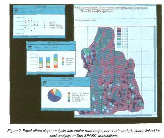
That venture didn't survive the oil & financial crash of '86, but I joined another startup publishing oil data on then-new CD-ROMS called CDpubCo. Using a hashing algorithm originally from the Texas School Board, allowed to publish all of Alberta, W CAN oil&gas wells on one CD and production data on another, in a form factor affordable for independent and junior oil cos. (read: everyone but oil majors who dedicated entire IT depts. to petro-data). We were also an alternative to online data vendors, whose delivery model was crunchy to put it kindly pre-internet on 4800 bps modems! I then met my old friends from CalCAD days who set up StrataWeb, a brilliant idea to publish maps on the still-brand-new Web, that would give a map front end to CDpubCo. That didn't gel and I left, only to see the same attempted thru an expensive Alberta Research Council grant - case in point where guv grants don't necessarily save money for taxpayers - but by then joined to DataSpan who inherited Teknica's old drum scanner and I tried to revive my previous attempt at digital data capture. I later teamed up with Facet Decision Systems in Vancouve and Axion Spatial Imaging in Edmonton, who had brilliant GISes that were object-oriented spreadsheet and flight system respectively... W Canada was sure a hotbed of innovation in the 90's!
A small engineering firm also had a proto-GIS - hand-scripted mapping and database connectivity but no geo-analytics yet - Munro Garrett was purchased by Landmark then by Halliburton, and took me to Dallas, Houston and Greater London, with projects from Bakersfield thru Baku to Bangkok... with sidetrips to Calgary and Maracaibo... deploying a Unix then Windows GIS using Esri's ArcView... we sold the most runtime globally before Y2K!
That landed me with Esri itself in the new millennium, where I spent over 5 years in So. Cal. travelling again regularly to Moscow, Rio and the Middle East but not Europe - that was covered by my former HAL comperes' start-up right about when I left London - my success in petroleum (exploration & production) led me to pipelines (transportation and distribution), but disaster response (Tropical Storm Allison and Hurricane Katrina) overstretched me... That combined with green-carding stalled since 9/11 and we repatriated in-extremis 15 yrs ago, with repercussions described on my old website here.
So I thought of London as the hotbed with petroleum interest swinging East towards BRIC (Brazil, Russia, India & China), and my current in-laws kindly put us up briefly until we found our footing near Cambridge 1 hr. North of London. That didn't translate into stable work, tho I managed to join small firms, help a second startup called Oilelefant.com - you guessed it, petro-data on web maps - and two delightful years in Kuwait (helping local Esri distributor) and Sunbury (returning to bp where I had done a Y2K project prior). I then diversified into business process re-engineering with LINQ, another startup by former Esri comperes, under my own banner zolnai.ca; you see, a former boss' wife now an ISP provided a stable Internet home for web & e-mail for the last twenty years as I bounced around the world, and an address aliasing this blog.
As my old website indicates, Brexit killed my business as prospects stopped planning and budgeting in the uncertainty preceding the mid-2016 referendum. That tuned into a perfect opportunity to leave "da awl bidness" and look for something locally, after working abroad for so long.
Two things happened almost at once. I met Terry Jackson with whom we planned a non-profit to address this:
How can we foster local business and community engagement, by providing open access to local geographic and environmental data that are time stamped?
That had me parlay the East Anglia geo-historic landscape I had started a decade earlier, and cast it in climate change and later pandemic terms, using story maps as a prime vehicle:
This went hand-in-hand with joining Extinction Rebellion to become a scientist, where I switched from marching in the streets to leverage the outreach I already performed as a Quaker. Here is an info video:
The long and winding road
So from my original startup in 1986 that launched my GIS career, through helping two more in CD then web publishing in 1988 and 2009 in Calgary and London respectively, to starting a non-profit in 2019 along the Fen Edge two villages north of Cambridge UK, it's been a long journey from resources data management to climate change mitigation. I have been lucky, however, to be able to contribute as a geologist all along.
No comments:
Post a Comment
Thanks for reading! Please share in Comments your questions & stories...


No comments:
Post a Comment
Thanks for reading! Please share in Comments your questions & stories...