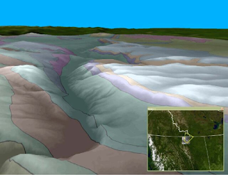
This follows on the previous post here of an ongoing series of maps created for outlets that aren't necessarily on the web - see label:revisit here and label:3D here - this is partly because I'm disengaging from socials; and that itself was partly because I had to let go of significant chunk of work on the internet for lack of resources (see §2 here). See my remaining web presence in the banner menu of the web view here.
My web presence
Wednesday, 15 October 2025
Saturday, 22 February 2025
East Anglia Peatlands revisited
Update1: see clipped oroginal and working vector datasets posted as detailed at bottom.
Update 2: added DIY map-mapping workshops & notes to help citzen science
Update 3: here at the end is the relevance of this sort of effort in a broader context
Update 4: worrying revisit of peatlands degradation with increased drought & extreme weather here: increased heat degraded carbon absorption, and that is mirrored in tropical forests turning into carbon emitters seen here
***
This follows on previous Peatlands blog posting here, last of the Community Engagement Series.
As news abounds about Arctic Permafrost & Peatlands degrading faster than thought (Copilot), this may be a good time to bring back some Natural England and Environment Agency data under Open Government License (OGL, National Archives). The upshot is that returning peatlands to their original state is the biggest climate change mitigator in the UK detailed here & here: briefly, peatlands either degraded thru neglect or converted to farm land, not only shrinks & stops being floodwater catchment, but it converts carbon sinks through sphagnum moss into carbon emitters thru windborne dried peat. In other words, re-watering peatlands dwarf efforts from other mitigation of climate change (see sources at bottom).
Thursday, 30 November 2023
Fun with puzzle maps, part II
Having moved from Cambridge to my family home in SW FR, I found the historic map puzzle i described here on a previous visit.
Tuesday, 20 June 2023
A brief history of mine
Update 2: see my journey on the web here.
Update 1: a duo of posts on my Medium professional channel here relates my early computing.
As I go through a 'hard reset' in my life and plan to exit social media, this may be a good time to pause and reflect on my IT journey.
 |
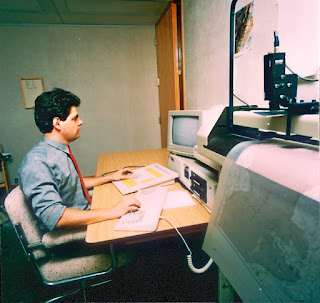
| Calgary 1986 see here |
Anecdote 1: as an undergrad at University of Calgary, I learned of Ted Nelson's Xanadu project (here), to catalog the world's information via what later became Hypertext Markup Language (HTML) - few people realise Tim Berners-Lee didn't invent anything, he built on exisiting systems... as we all do - but Nelson was a propeller-head who couldn't market his idea (here). John Walker, co-founder of Autodesk, reportedly bought the technolgy but it never got anywhere... I heard of this as I was cooling my heels awaiting to meet him, with Carol Bartz his then PA - the same who eventually lead Autodesk then Yahoo, a true pioneering woman in IT - when a surveyor friend and I tried to sell them the idea of a mapping front-end to AutoCAD ... in 1986! Remember MS Windows was launched just the year before (see Side Story here and illustration here incl. photo above). Did you know I received a copy of Windows v.1.O as part of a hardware upgrade to boost my computer's memory from 640Kb to 1Mb?! Sidebar: Was Bill Gates not famously quoted that no personal computer would ever need over 640Kb RAM (here)?
CD-ROMs
Anecdote 2: Microsoft was largely credited with popularizing CD for software distribution. While that is true, the real initiative was the US Dept. of Defense - the same people whose DARPA developed the precursor to the internet linking US military to government contractors, chiefly universities in the beginning - the reason? In the Cold War era, it was feared the Soviets might detonate an atom bomb at 5-10 mi. altitude that would fry the entire electronic infrastructure of mainland US, thus disabling the military - oh! and the rest of the country is collateral - I learned via the USGS mentioned above, that CDs were immune to resulting electromagnetic pulses.
Anecdote 3: as I had been on contract to the Geological Survey of Canada Calgary office across from the university, we visited the geological library and offered to scan the index cards to electronically catalog them on CD-ROM - after all our software came from a school library application - do you know what the librarian said then? "If we made the catalog that easily accessible, can you imagine the amount of work that might create?" We obviously had work to do, convincing a traditional business of the advantages of electronic access, taken for granted now!
Pre-WWW
Standards & Metadata
Volunteered Geographic Information
Wednesday, 28 July 2021
Unlocking Open Data from a legacy site
In the process of looking at land cover per previous post, I found Natural England's Natural Capital Atlas - their story map encouraged me to enter EsriUK's latest competition - their Esri dataset is accompanied by ample documentation under data.gov. To save us reverting to ArcMap, let's use the provided layer files and a file geodatabase in three simple steps to map our own region on ArcGIS Pro.
Saturday, 29 December 2018
Challenger Expedition DIY Web Map
Let's look at now creating complete maps in AGOL from publicly available data, and analyzing it over time to see their historic significance. This results in this web map of the HMS Challenger 1873-1876 Expedition:
Sunday, 25 September 2016
"They call me the cleaner"
I refer to the character Victor played by Jen Reno in Luc Besson's 1990 film "Nikita".
Saturday, 4 June 2016
When is a map not a map, Part II
Sunday, 9 November 2014
A day in the life of a petro-data manager - intro
Have you ever been given plain text geodata and wondered how to database and map it? And has this happened to you lately with tens of thousands of lines of data? Well help is at hand! Here is an ETL workflow (extract, transform, load) useful to any data manager in or out of petroleum using free tools:
Sunday, 16 March 2014
Releasing data really works, Part VI
Sunday, 23 February 2014
Global Sailings (1662 - 1856, English, Spanish, Dutch, French) revisited
I originally extracted CLIWOC (CLImatological database for the World's OCeans) ship captains' logs ships locations over a decade ago, to demonstrate the processing of 250K+ points in ArcGIS desktop using then new File Geodatabase. Five years later I posted this on my old website with instructions how to use it in old ArcGIS Explorer and KML, and then I put a layer package on arcgis.com - both related historic details like de laPerouse's demise below, the importance of data standards and metadata, and the interst it generated elsewhere - more recently I posted a time-based variation of same, where using a time slider helps clarifiy complex data on desktop GIS.
Saturday, 18 January 2014
Standards & Metadata, Part VIII
Sunday, 15 December 2013
Releasing data really works, Part V
Saturday, 17 August 2013
To Geo or not to Geo, that is the question...
Thursday, 29 December 2011
On-line spatial data validation, part II
Three weeks ago I introduced Socium's Online Validation Service (OVS). I showed the Ordnance Survey vector data QC, on the UK Parishes used as a geographic unit for the Medieval Fenlands project. Two weeks ago Socium kindly created a new rule, to post unexpected variations in adjacent feature attributes. In an essentially agricultural era, economic wealth of the Domesday period was quantified by Darby via the number of plough teams per parish. That is the attribute the rule was written for (it's hard-wired right now and Socium plans to add metadata pick lists in the future).
Saturday, 8 October 2011
Clouds gathering over the horizon, part V
Thursday, 18 August 2011
Simple Feature or Full Feature Specification for OGC?
Friday, 13 May 2011
More temporal web maps
Monday, 25 October 2010
Trending oilelefant.com, part VI
Thursday, 21 October 2010
"Better metadata for GIS"
We are going to see much more improved "metadata" system for geo-graphical data - which will help integrate it much more closely with bigger information management systems, writes Andrew Zolnai, sales and marketing director, Interactive Net Mapping Ltd.


